
Know Your Soils: Woodland Tour Explores Growing Maine's Most Perennial Crop

By Jeanne Siviski
Eli Berry refers to thinning carrots and selectively cutting trees in the same breath. To him, managing his woodlot and gardening can be one and the same.
Berry was one of several speakers at “Beyond the Field Edge: Farming and Maine's Most Perennial Crop,” a workshop about deciding where to farm or grow trees based on soil type.* For the outdoor portion of the workshop, participants toured soil test pits at Berry’s property.
Located in the town of Washington on a flat-topped ridge, it’s a 74-acre parcel Berry’s grandparents acquired in the 1950’s. An old farmhouse and barn sit near the road. Behind the house, a cluster of small, innovative, energy-efficient dwellings form a miniature shtetl where Berry and his family live.
Pointing out stonewalls which closely parallel boundaries between soil types, Berry says that farmers of days gone by had a lot of knowledge about soils and did not waste time working unsuitable ones. Signs of Berry’s own efficiency can be seen on the landscape, neatly sorted and stacked wood, a peeled balsam fir fence that straddles an old stonewall on the edge of a cow pasture.
On the test pit tour, Berry speaks about thinning trees. “People are often afraid to cut. It’s part of the weeding process,” he says, returning to the garden analogy. Berry does have a garden, and he does thin carrots, mainly for his family’s consumption. Berry works as a low-impact logger using a lot of hand tools. They sell firewood, saw logs, tools, Christmas ornaments and seedlings.** Turning lemons into lemonade for Berry is thinning out hemlocks before they grow too big by harvesting them as seedlings and selling them.

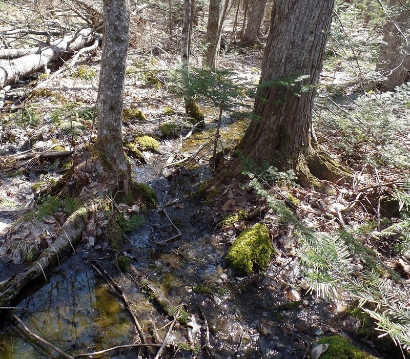
A high seasonal water table exists at the first test pit site. The land has a “pits and mounds” topography with trees growing on the elevated mounds. David Rocque, the Maine State Soil Scientist, places two soil samples, one from a pit and one from a mound, side-by-side. “The longer the soil is wet, the greyer the color,” he says to explain the difference between the two samples. The grey color occurs as iron is reduced and leached from the soil. It’s level land and water pools on top of the hard pan glacial till, soil that was compacted, or “squashed” by the glaciers.
“It’s not an understocked site by any means,” Maine District Forester Mort Moesswilde says, pointing out some healthy pines. But at the next stop, there are more pits than mounds. Roots can be seen, exposed on the top of the ground. It is determined that red maple, also known as swamp maple, would do well here. Anaerobic environments created by soils that remain water-logged can be toxic to plants that have not adapted to growing in such conditons.
“Trees are like any other crop,” Rocque says, in that they thrive with specific soil conditions. He warns against “shoe horning” trees in places where they won’t be happy. Rocque recommends that woodland owners make use of Web Soil Survey, an online tool that creates personalized soils maps, to determine what grows best on their property.***
Soils from an additional test pit on the hill top show signs of agricultural modification. The topsoil layer has a consistently dark brown coloration without variation. The land has a smoothed out look. Rocque deems the site suitable for growing almost anything.
Berry’s land slopes down to Davis Stream, a tributary of Damariscotta Lake. A soil sample on the hillside is brighter and more oxygenated with varied dark and light hues that indicate the presence of oxygenated groundwater. There is no dark brown topsoil layer in this soil because it was too wet to farm. Berry says this area is “on the edge of operability” because of slope and access. Moesswilde sees it as a good place to manage for what is there, hemlock, yellow birch, hophornbeam and sugar maple.

Further down the hill, Berry leads the group through what he refers to as “deep, dark, primordial woods.” Its’ a steep, bony hemlock stand dominated by an enormous pasture pine. For Berry, value already exists in this piece of land that he remembers visiting as a kid. This is a rolling landscape with drainages between high and dry ridges. A soil pit on a ridge has a dark brown topsoil layer due to pasturing in the past, with brightly colored soils below, indicating good drainage and a highly productive soil.
The final test pit sites are a stone’s throw from Davis Stream. It’s a pristine area. Shaded by overhanging brush, crystal-clear water makes its way around a bend. An understanding of soils, Rocque points out, is also important for avoiding water quality violations and the penalties they carry. Erosion, he says, can accidentally alter the hydrology, sending muddied water to the brook “in a hurry.”

Rocque pauses at the test pit closest to the foot path. It’s a prime example of what all Maine soils would have looked like before they were altered. It has a thick organic duff layer over a thin gray layer with a dark reddish brown layer at the bottom. The thin gray layer develops due to organic acids from rainwater and snow melt leaching down through the organic duff layer. The iron, organic matter and other soil coloring materials precipitate out in the layer just below the gray layer. In farmed soils, these topsoil layers become mixed together and darkened by organic matter. In Maine, he says, we do not have a naturally occurring dark brown topsoil layer unless the soil is poorly drained. At one point, 80% of Maine was cleared.
Berry feels it’s important to be aware that we are working in an altered landscape. He is deeply involved in managing his land. Like a gardener, he observes effects of the weather and everything that impacts the landscape. He encourages people to keep a day book and record notes about their property. “Your habits are what make your habitat,” he says. One habit he recommends is leaving it better than you found it.

*This presentation of “Beyond the Field Edge: Farming and Maine's Most Perennial Crop” was presented on Friday, April 15. The workshop was supported by grants from USDA-Natural Resources Conservation Service (NRCS) in partnership with Knox-Lincoln Soil and Water Conservation Service (Knox-Lincoln SWCD) and Maine Organic Farmers and Gardeners Association (MOFGA), and co-sponsored by Maine Coast Heritage Trust (MCHT) and Maine Woodland Owners.
The program itself is delivered by the Maine Forest Service and the Department of Agriculture, Conservation & Forestry, and is available for presentation to interested groups around the state, including SWOAM chapters, other Soil & Water Conservation Districts, Granges, etc.
**The contact information for Eli Berry’s tool business is Human Powered Forestry Tools, 207-242-5927 or 1970eliberry@gmail.com
***After opening the Web Soil Survey link, click on the round green start button to make a map. Type in your address, and follow instructions. Because this mapping device is based on large-scale analysis, it does not take into account local variation and is not one hundred percent accurate. It is recommended as a starting point for learning about soils.